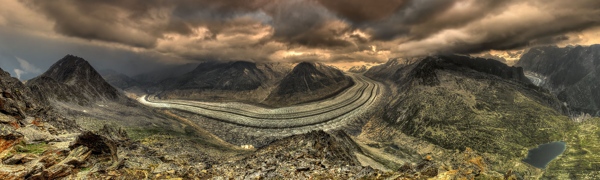
The panorama of the Aletsch Glacier and the Fiescher Glacier in the Swiss Alps belongs to the most spectacular mountain landscapes in Europe.
The promising thunderstorm conditions in August 2015 were ideally suited to photograph this panorama from the summit of the Eggishorn (2,869 m, 9,413 feet). The active thunderstorm line was still about 6 km (3.7 miles) away while these images were taken. The heavy rainfall of the thunderstorm can be seen in the unstructured gray clouds at the left side of the image behind Bettmerhorn (2.857 m, 9.373 feet). This seemingly left enough time to complete the 57 individual shots of this 220° panorama and to start the descent from the summit in time.
However, what was not visible even to the trained meteorological eye in this dynamic and rapidly changing cloud cover was the new formation of a thunderstorm cell directly above the Eggishorn. Working behind the sturdy metal tripod I first noticed a tingling sensation running from my feet up to my head, whereupon my hair stood up. What I felt was the pre-discharge of the building up lightning channel running from bottom to top. Intuitively, I threw myself to the ground, but immediately recognized that the metal tripod was now standing above me. At the same moment there was a deafening bang as the lightning struck and the thunder rolled through the wide glacial valley and echoed back from the opposite mountain walls. As I slowly rose, I noticed flames of St. Elmo’s fires sparkling from my fingertips. These rare and ghostly light phenomena, caused by electric charges, gleam blue-violet due to the spectral lines of the atmospheric gases oxygen and nitrogen. Never before had I come closer to being struck by lightning. I could literally smell and taste the electric charge inside and around me while my body was flooded with adrenaline. In feverish haste I finished the missing two shots of the panorama, threw the photo equipment unsorted into my backpack and rushed from the summit towards the valley, when the next lightning bolts already struck way too close. On the way down the heavy rain finally poured down on me. But the thunderstorm gradually lost its activity and gradually drifted away.
With a length of 22 km (13.7 miles) and a width of 1.500 m (4.900 feet), the Aletsch Glacier is the biggest and longest glacier of the European Alps. Its melt waters flow through the Massa gorge into the Rhone. The glacier has its origin at Konkordiaplatz in the Jungfrau region at an altitude of 3.800 m (12.467 feet). Its cold accumulation zone can be seen where the pale yellow light of the sun illuminates the glacier. This region receives more snow in winter than can melt in summer and is where the glacier grows. The numerous dark bands that give the glacier its characteristic appearance are medial moraines. They are formed where the individual glaciers that form the ice stream meet and merge. The erosion debris carried by each glacier at its margins collects along these medial moraines. Where these bands first become visible up-slope, the equilibrium line is located at which the air temperature averages 0°C (32°F). Below this line lies the much larger and warmer ablation area. This is where more ice melts than is supplied by the accumulation area. The view upon this ice giant thus reveals that its mass balance is in poor conditions. At the end of summer, its medial moraines are visible up to the highest elevations. The darker the ice surface becomes, the more its surface warms up and the faster the ice melts. This self-reinforcing feedback effect causes the ice to melt ever faster as temperatures continue to rise.
Climate change is leaving its clear imprint on the Aletsch Glacier. Its condition reflects the global thermometer of our planet. During the peaks of the last ice ages, the Aletsch Glacier filled the entire valley. Wherever the rocks are exposed today, the valley was covered with ice. Only the jagged and rugged peaks, protruded out of the ice system.
During the ice ages the shape of the glacier was not determined by the relief of the ground upon which it rested. In the year 1850, at the last peak level of the Alpine glaciers, the ice of the Aletsch Glacier was located approximately 100 m (330 feet) higher than today. This ice level can still be recognized today by the vegetation-less lateral moraines and rock faces that brightly contrast against the much darker rocky areas above. Since 1850, the glacier has retreated more than three kilometres (1.9 miles). At the end of the tongue, the glacier is currently losing about 10 m (33 feet) in length per year. In hot summers, however, it can be more than 100 m (330 feet). Its flow velocity varies between 50 and 180 m (164 to 590 feet) per year, depending on the location of measurement. The thickness of the ice varies between 900 m (2,950 feet) at Konkordiaplatz and 150 m (492 feet) at the terminus of the glacier. Climate projections suggest that by the end of the century the Aletsch Glacier will have disappeared in its coherent form.
In the area of Moosfluh towards the terminus of the Aletsch Glacier, the strong glacial retreat causes instabilities of the mountain slopes. This slowly moving landslide could even trigger a massive rockfall. The retreating glacier can eventually no longer stabilize the surrounding mountain slopes. In addition, the permafrost is retreating from the bedrock. This in turn allows rain and meltwater to penetrate deeper into the rock and further destabilize it. Frequent freezing and thawing processes continue to rapidly erode the bedrock. Such frost-change days now occur on more than half of the days throughout the year in the Aletsch Glacier area.
In the basin between the Eggishorn and the Strahlhorn the small lake Märjelensee is located. At the glacier’s peak level in 1850 the Märjelensee dammed up to a glacial lake that repeatedly and abruptly emptied through open channels in the crevasses of the glacier. This caused torrential flash floods that cascaded through the Massa gorge into the Rhone valley. In contrast, the larger lake Vordersee is a recently dammed water reservoir.
On the far right side of the image, the 4,274 m (14,022 feet) high Finsteraarhorn is illuminated by the sun in the pale yellow thunderstorm light. The 14.8 km (9.2 miles) long Fiescher Glacier has its origin in this mountain range. It is the second longest glacier in the Alps after the Aletsch Glacier.
The feeling of experiencing this stormy atmosphere on the summit of the Eggishorn high above the Aletsch Glacier was intoxicating. The looming light of the scenery and the incisive experience of almost being hit by lightning made the adventure behind this shot unique and unforgettable.